Namibia had lived in my imagination long before it became a stamp in my passport.
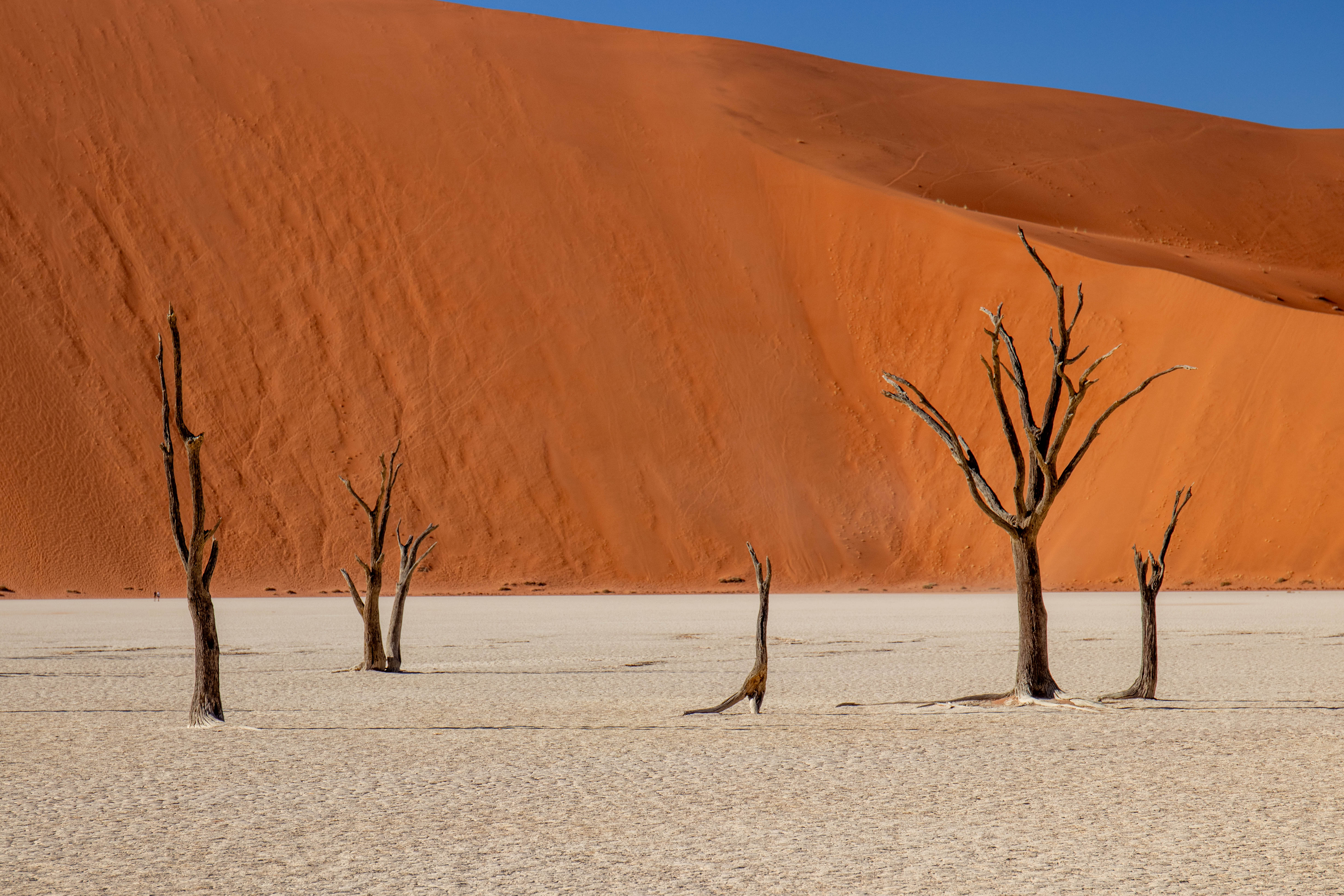
It started with a photograph. In 2011, National Geographic ran an image of Dead Vlei on its cover — black skeleton trees rising from a white clay floor, surrounded by dunes the colour of burnt copper, under a sky so saturated it barely looked real. I was young, but I remember staring at it convinced I was looking at a painting. The geometry was too perfect. The contrasts too deliberate. I kept coming back to it.
Namibia ended up being the first African country I visited, years after that photograph first caught me. I’ve since travelled to several others across the continent, and Namibia is still the one I’d recommend someone to head to first.
This 2-week Namibia itinerary follows the loop I took: south to the Namib Desert and Dead Vlei, west to the Atlantic coast, north through Damaraland and Etosha, and back to Windhoek. It’s enough time to see the full range of what makes the country worth the distance, without rushing through it.
Table of Contents
Namibia: A Country of Extremes
Namibia was one of the first African countries I visited — and in hindsight, it set the bar dangerously high.
This is a place of genuine extremes. It’s one of the most sparsely populated countries on Earth, covering roughly twice the area of Germany with fewer than 3 million people. The Namib Desert, which runs the length of its Atlantic coast, is the oldest desert in the world — estimated at over 55 million years. In the hottest months, exposed surfaces in the desert exceed 50 degrees Celsius. The distances between major stops can run to five or six hours of driving on roads that include sealed tarmac to corrugated gravel.
The itinerary I followed ran clockwise across the country: south from Windhoek to the Namib Desert and Dead Vlei, west to the Atlantic coast at Swakopmund, north through Damaraland, then east to Etosha National Park, before circling back to Windhoek. Two weeks in total, and it was just enough to experience the variety the country offers.
Basic geography of the country:
- South: Desert, Dead Vlei, towering dunes, sparse but distinctive wildlife
- West: Coast, a completely different climate, seabirds, marine mammals, delicious seafood
- North: Safari country, Etosha National Park, wildlife in real numbers

Windhoek
We spent one night in Windhoek before starting the grand tour of the country.
Most visitors treat it as a transit point, and I understand why. There just aren’t that many tourists here compared to bigger African cities, which means fewer people and less traffic than you’d expect from a capital. What struck me instead was the architecture. Germany ran the country as a colony from 1884 until the First World War, and Windhoek still looks like it with wide streets, government buildings with a distinctly Wilhelmine character, Lutheran churches in pale sandstone. It’s an odd thing to see in Africa. If anything it reminded me a little of Australia: that same sense of European colonial architecture dropped into a completely different climate and landscape, still standing as it was built.
Christ Church (Christuskirche), built between 1907 and 1910, is the city’s most photographed landmark. It’s not the grandest cathedral I’ve ever seen — I’ve stood in front of bigger, more elaborate ones across Europe — but it’s a striking standalone structure in pale local sandstone, neo-Gothic and Romanesque pieces stitched together, and in the evening light the stone takes on a warm amber tint. Worth a slow walk around. The small garden in front of it is a good place to sit and take stock before the road swallows you up.
For dinner, we picked Joe’s Beerhouse. It’s well known for catering to tourists, and the menu is the reason: oryx, springbok, kudu, ostrich, crocodile, alongside more familiar options. The place is big, with both indoor and outdoor seating, and busy with a mix of tourists and locals, though it never actually felt overwhelming. We booked a table in advance, so we were seated right away instead of waiting it out by the door. I ordered the kudu — I’ve had plenty of game meat before (reindeer among others), but never kudu specifically. It’s close to venison: lean, quite gamey, more flavourful than beef. It was a great spot for the more adventurous eaters. Most of what was on the menu, we’d be looking for in the wild soon enough.
South: The Namib Desert and Sossusvlei
The road from Windhoek south to the Sossusvlei area takes roughly five hours. It begins in the relatively green central plateau with acacia scrub, occasional farmland, red soil, and then gradually strips itself back. The vegetation thins and flattens. The palette narrows. By the time you’re approaching the gates of Namib-Naukluft National Park, the landscape has become almost entirely ochre: sand, rock, and a pale sky too large to properly register. The park itself covers nearly 50,000 square kilometres, making it one of the largest protected areas on Earth.
The Helicopter Flight
Before arriving at the dunes, I’d arranged something worth the advance effort: a small helicopter flight from the Sossusvlei area out toward the Skeleton Coast. The helicopter takes only three passengers, and weeks ahead of the trip I’d requested the doors be removed. I know it sounds crazy but it makes a real difference for photography, no plexiglass distortion, no reflections, no frame between you and the landscape below. The trade-off is the wind, which was considerable once we were up. You keep your camera and phone on wrist or neck straps, because you genuinely cannot afford to lose your grip on either.
From the air, the Namib Sand Sea reads as something between a painting and a geological diagram. The dunes form in patterns that aren’t visible at ground level: long, rippled ridgelines, star dunes radiating from a single point, interdune corridors stripped pale by wind. The colours shift constantly with angle and moisture — from washed-out apricot in the flats to a deep terracotta on the exposed faces. At the coast, where the dunes run directly into the Atlantic, the contrast is vertiginous. It looks like two separate worlds colliding without transition.


Book the flight well in advance. Door-removal requests require early notice and are subject to weather on the day.
Dune 45
The next morning, we set off before sunrise with a guide from the lodge — a shared tour, but one that only exists because Little Kulala has its own gate into the park, ahead of the public entrance at Sesriem. We stopped at Dune 45 first.
Forty-five kilometres from the Sesriem gate, Dune 45 rises about 170 metres from the surrounding plain and is accessible enough to draw large numbers of climbers at dawn. The ascent is leg-burning on shifting ground — two steps forward, one sliding back — and the sand is cold before the sun reaches it. At the top, the reward is a view across a corrugated sea of dunes in the first light: the west-facing slopes still in shadow, the crests catching the pale golden morning light. It is not a difficult hike, but it’s beautiful.
Dead Vlei
Dead Vlei — its name meaning “dead marsh” in a mix of English and Afrikaans — is a white clay pan located near Sossusvlei in the Namib-Naukluft National Park, tucked into a valley between the dunes. The story of how it came to look the way it does is worth knowing before you arrive, because it makes the silence inside it mean something.
The pan was formed when the Tsauchab River used to flood, creating temporary pools where camel thorn trees grew for centuries. Then the climate shifted. A prolonged drought arrived, sand dunes encroached on the pan and blocked the river from reaching it, and the trees died — starved of water, unable to recover. In an ordinary landscape, dead trees decompose. Here it became too dry even for that. The trees simply scorched black in the desert sun, preserved by the same aridity that killed them. The skeletons you see today are estimated to have died 600 to 700 years ago. The trees themselves were already around 300 years old when they perished. They have been standing, unchanged, for longer than some civilizations.
The surrounding dunes reach 300 to 400 metres — among the highest in the world. The tallest, called Big Daddy, rests on a sandstone terrace and looms over the pan’s southern edge.
The walk in from the car park takes about fifteen minutes across soft sand. The moment you crest the low ridge and the pan opens below you, most people stop talking. I’d seen this exact place on the cover of a National Geographic years earlier, back in my early teens — and the day before this, from the helicopter, I’d seen it again from above. Standing at the edge of the pan now, at eye level with the trees themselves, felt like closing a loop that started with a magazine cover I couldn’t stop staring at. What strikes you next, once that settles, is the silence: the dunes absorb sound the way deep snow does, and on a calm morning you can hear your own footsteps with a clarity that feels slightly unreal.
I walked directly into the pan rather than climbing Big Daddy first. Dune 45 had already given me the elevation experience that morning, and there was also something I wanted to feel from ground level — the sense of being surrounded rather than above. Standing among the trees, each one a different silhouette against the dunes, the scale becomes physical. The walls of sand are so high they shift the light. Late morning, the best angles are already going. Go as early as the park gates allow.

Access requires a 4×4 for the final section, or a transfer with the park’s own vehicles. Take considerably more water than you think you need. The shade is non-existent.
Where to Stay: Little Kulala
For the Sossusvlei section, I stayed at Little Kulala, a Wilderness Destinations property set on the 37,000-hectare Kulala Wilderness Reserve, which shares its boundary directly with Namib-Naukluft National Park.
It’s a sanctuary that opens with a bright, welcoming reception, chalets spaced far enough apart that you genuinely feel like you have the reserve to yourself, and meals served on a terrace looking straight out at the waterhole.
The interior draws its palette from the surrounding geology. Nothing here is trying to look modern or futuristic. It’s luxurious, but restrained enough that it fits into the landscape rather than competing with it.
The decisive logistical advantage is the private gate. Little Kulala is one of the few camps in the region with exclusive direct access to the Sossusvlei dunes, which means guests are consistently among the first to arrive at Dead Vlei and Dune 45 each morning, ahead of other tourists coming through the public Sesriem gate. We’d already had Dune 45 to ourselves before the first coach-loads arrived.
On each of the individual chalet, there is a rooftop star bed. And this is what most guests remember longest. I spent both nights outside rather than in. Namibia sits in one of the darkest regions on Earth — the population density is so low, and the nearest city far enough away, that the night sky appears without the veil of light pollution most people have grown up with. The reserve has been described as one of the darkest places on Earth for stargazing. The Milky Way was a structural feature of the night sky — a visible river of light with depth, texture, and the sense of actually looking into something rather than at it. Visit when there is no full moon. A full moon is beautiful in its own right, but it competes directly with the stars and reduces the effect considerably.
In the late afternoon, the waterhole visible from the main lodge drew oryx and jackals, barely lifting their heads as we watched from the terrace.


Minimum recommended stay: two nights. The private access to the dunes and the rhythm of early mornings, afternoon stillness, and night skies needs time to settle into. One night is simply not enough.
West: Swakopmund and the Atlantic Coast
The drive from Sossusvlei to Swakopmund crosses one of the more abrupt climate transitions I’ve encountered anywhere. The desert interior, with its 40-degree days and total absence of moisture, gives way gradually to a coastal strip shaped by the cold Benguela Current pushing in from the South Atlantic. Temperatures drop by 20 degrees or more. Fog rolls in from the ocean each morning. The light turns grey and northern.
We stopped at a lagoon on the approach to town. Hundreds of flamingos stood in the shallow water, impossibly pink against the grey light.
Swakopmund
Swakopmund is an anomaly. It was founded as a German colonial port in 1892 and retains a built environment that still reads as Wilhelmine Central European — gabled facades painted in faded pastels, wrought-iron balconies, a town hall that would look at home in Bavaria. But it’s the climate that throws you off more than the architecture: cooler, damp, distinctly un-desert-like after where you’ve just come from. The ocean itself isn’t a beach-holiday ocean either — it’s colder and moodier, the kind of water that’s clearly built for wildlife rather than swimming.
The town functions primarily as a base for coastal activities — ocean tours, quad biking, sandboarding, dune buggy excursions — and as a cooler-weather retreat for Namibians from the interior. The Swakopmund Gem and Mineral Museum, housed in the old railway station building, is small but worth a stop: Namibia sits on some of the world’s most mineralogically rich geology, producing diamonds, uranium, amethyst, tourmaline, and unusual crystal formations, and it’s genuinely interesting to see the range up close and understand how they actually formed.
The Ocean Tour
One morning I joined a boat tour out into the bay. The temperature was around 10 degrees Celsius. Having sweated through 40-degree days in the desert two days earlier, the cold registered as almost comical. I wore a down jacket, and I definitely needed it.
The cold comes from the Benguela Current, an upwelling of cold, nutrient-rich water from the deep South Atlantic. It makes these coastal waters extraordinarily productive — dense with fish, which in turn support enormous populations of seabirds and marine mammals. One Cape fur seal, clearly a regular, jumped straight up onto the deck looking for fish scraps and posed for as many photos as anyone wanted to take. Others played in the water around the boat the whole way out. Pelicans drifted overhead. Two African penguins appeared briefly. The species is now critically endangered, with fewer than 10,000 breeding pairs globally, which made even a brief sighting feel significant.

Halfway through, the crew brought out fresh Namibian oysters, pulled from the water that same morning. They were big and creamy, milder than the ones I’ve had in France, but the freshness more than made up for it. Also the mellower flavour meant I could easily have gone through a dozen without getting tired of them.
The Dune Tour
In the afternoon, a tour in a 4×4 traced the coastline south into the dune belt where the Namib meets the ocean. The guide’s particular interest was the micro-fauna of the coastal desert — species that exist only within this specific climatic corridor and not really anywhere else on Earth.
At one point the guide dug a small pink gecko out of the sand, its body half-transparent. He explained you can only find them on overcast days like this one. Direct sun exposure is too much for them, so on clear days they stay buried where you’d never see them at all.
Then came the part I’d actually been waiting for: driving the dunes themselves. Steep climbs, steeper drops — the kind where the car briefly loses its grip on the way down before the sand catches it again. There’s no single ridge you’re aiming for; the dunes here naturally form ridgelines, and each one works as its own lookout as you climb. The car did the heavy lifting to get us up there, but we got out and walked around at the top, looking out over where the dune belt runs straight into the Atlantic — sand simply giving way to water, with nothing in between.

As the light started to drop, our guide found a quieter sundowner spot. We sat with drinks in hand as the sun turned the dunes a deep gold. Quiet, no crowd, nothing to do but watch the colour change.

Cape Cross
On the next morning we drove north toward Damaraland, we stopped at Cape Cross, which is roughly 120 kilometres up the coast from Swakopmund. In 1486, Portuguese navigator Diogo Cão became the first European to visit this stretch of coastline, erecting a stone padrão to claim the land for the Portuguese crown under the orders of King João II. The cross that stands today is a replica; the original is in Berlin. The history is the kind of detail you absorb briefly at the interpretive panel and then forget, because what’s in front of you demands your full attention.
Cape Cross is home to one of the largest Cape fur seal colonies in the world. More than 200,000 animals concentrated on a stretch of rocky shoreline that the Benguela Current keeps reliably fish-rich. Bull seals arrive in late October to claim territories and mating rights; pups are born in December.

The smell arrives before you see anything. A dense, concentrated mixture of salt, fish, and animal — rich and blunt and impossible to ignore. Wooden walkways bring you close: close enough to see individual faces, close enough to hear the particular sound a large bull makes when another animal gets too near. Mothers nursed pups a few feet from the walkway. A little further along, a seagull worked at the carcass of a pup that hadn’t survived. Animals dove in and out of surf that would be dangerous for a human swimmer.
It smells absolutely terrible, and it’s one of the most alive places I visited in Namibia. Birth and death sitting a few metres apart, neither one hidden from view.
North-west: Damaraland
Damaraland is the north-western interior. The landscape is all burnt rock and dry riverbeds, flat-topped mesas on the horizon, sparse vegetation that somehow persists without any apparent moisture source.
The temperature climbs back up fast once you leave the coast behind. After a few days of fog and cold in Swakopmund, we were back in close to 40-degree territory almost as soon as we turned inland.
The Desert-Adapted Elephants
The defining reason to come to Damaraland is to find its elephants. These are African bush elephants — not a separate species — but a population that has adapted over generations to conditions that should be incompatible with an animal of their size. Most elephants require enormous quantities of water daily. Damaraland’s elephants can go without drinking for up to three days, covering vast distances between sources and digging into seemingly dry riverbeds to extract water from underground. They have proportionally larger feet for moving across sand and gravel. Their knowledge of water sources — which riverbeds hold subsurface moisture, which seasonal springs are worth the journey — is passed down across generations, not instinctive but learned. It’s a strange thing to find one of the world’s most water-dependent animals thriving somewhere this dry, and that contrast is most of what makes them worth the trip out here.
The lodge normally sends several vehicles out in different directions each morning, all in radio contact, covering as much ground as possible until someone gets a sighting. We skipped that system and booked a private outing instead, with a guide confident enough in his own tracking to go it alone. It turned out to be the right call. He grew up in the region and speaks the local click language, and as we followed a dry riverbed on foot, tracing footprints, we passed a small settlement. He stopped and spoke to a young boy there — and the boy told him exactly which direction the elephants had gone that morning.
We followed the lead. A while later, we found them: several adults resting in the shade of a massive tree, some still digging steadily at the riverbed with their feet and trunks. No urgency, no acknowledgement of us. We were the only vehicle there, and we watched for a long time without speaking. Getting there by way of a stranger’s directions, given to a child in a language I didn’t understand, is not something you can book in advance — it’s the kind of moment you only get by having a guide who actually belongs to the place he’s tracking through.


Where to stay: Damaraland Camp
Damaraland Camp sits among granite boulders above a wide, rocky plain, with views that extend to mountains that turn violet at dusk. It is a simpler, more rustic property than Little Kulala — the accommodation is tented rather than villa-style, each tent built into the rocks with its own view of the surrounding plains, and the communal spaces are open to the landscape with no glass between you and the evening air.
The one real inconvenience: there’s no air conditioning, which stood out more than I expected in close to 40-degree heat. In practice it mattered less than I’d feared — desert evenings here cool down fast, so sleeping was never actually a problem, even without it.
What Damaraland Camp does well is the evening. Dinner is served outdoors around a fire, and the fire becomes genuinely necessary once the temperature drops. The other guests were mostly travellers with the same mindset — people who didn’t mind a bit of discomfort in exchange for what the place actually offers, and dinner conversation reflected that. The sky here is as good as anywhere in Namibia — no light pollution for hundreds of kilometres, and the altitude gives the air a clarity that even Sossusvlei didn’t quite match. I lay awake for a long time after dinner just listening to nothing and looking at everything.
Minimum recommended stay: two nights. Tracking desert elephants is not guaranteed in a single outing, and the landscape itself rewards time rather than efficiency.
North: Etosha National Park
Etosha is the part of Namibia that finally looks like the “Africa” most people picture when they think of a safari. This is where the actual wildlife sightings happen, the kind most travellers come to this continent for in the first place. The park holds four of the Big Five — lion, leopard, rhino, and elephant, but not buffalo, which need too much water to survive in a climate this arid.
That same aridity is exactly what makes Etosha so good for spotting them. The park covers 22,270 square kilometres (comparable in size to Switzerland) centred on a vast, shimmering salt pan that stretches 120 kilometres across its heart. More than 40 waterholes, a mix of natural springs and artificially maintained boreholes, are scattered around it, and in the dry season, they become the only reliable water source in the entire ecosystem. Everything — prey and predator alike — eventually has to come to them. After Damaraland, where finding elephants meant tracking them across a riverbed with a local guide’s help, Etosha is closer to the opposite kind of safari: less tracking, more waiting. Pick a waterhole, sit, and be patient, and the wildlife comes to you. That’s exactly what makes it such a good destination for a first-time safari. You don’t need specialist tracking knowledge or luck finding animals in dense bush. The animals concentrate themselves for you.


Elephants here carry a particular visual signature. Etosha’s white salt dust coats them as they move through the park, giving them a ghostly pallor that has earned them a nickname: the Ghosts of Etosha.
A note for planning purposes: the floodlit waterhole at Okaukuejo, inside the park itself, is one of the most reliable black-rhino viewing spots in Africa after dark. We didn’t see this ourselves — we were based on private reserves outside the park rather than staying at one of the government-run camps inside it, so our waterhole time was all daylight. If a night-time floodlit rhino sighting is a priority for you, that’s the detail to know: it means staying inside Etosha itself rather than at a bordering private reserve.
Where to Stay: Ongava and Onguma
Etosha’s own camps, inside the park, are government-owned — cheaper, but noticeably more rustic. We chose to stay instead at two private reserves bordering the park, Onguma on the eastern side and Ongava on the southern side, which trade a bit of that in-park convenience for a considerably more upscale stay.
Onguma The Fort, on the eastern boundary near Fisher’s Pan, was mostly a base for driving into Etosha itself rather than staying on Onguma’s own private land. Fisher’s Pan has a different, quieter character than the park’s central and southern sections — worth knowing if you’ve already spent time in the busier parts of Etosha and want a change of pace.
Andersson’s at Ongava, on the southern boundary, is where the trip’s best wildlife moment happened. It’s a fenced property, which sounds like a small detail but matters in practice — you can walk between reception and your room on your own, without an escort, which isn’t the case everywhere in this part of Namibia. On a game drive within the private reserve, we came across a small group of black rhino and got to within less than three metres of them. We stayed with them for about twenty minutes before heading back. It’s still the closest I’ve ever been to a rhino in the wild.
Between the two, allow at least three nights in this area total. Etosha is large enough that different sections feel genuinely different, and the private reserves reward time rather than a single frantic day.
Back Near Windhoek: N/a’an ku sê
The last stop before heading back to Windhoek is N/a’an ku sê, a wildlife sanctuary and conservation foundation about 45 minutes from the city on the airport road, set within a 9,000-hectare private reserve.
N/a’an ku sê was established as one of Namibia’s first charity lodges where all revenues support the foundation’s conservation and humanitarian work, including a free medical clinic serving the San Bushman community in rural eastern Namibia. The lodge’s chalets are comfortable and well-appointed, built close to the main dining area with views across the bush, and the reserve itself has free-roaming cheetah, leopard, giraffe, zebra, and plains game accessible by game drive.
The activities that define a stay here are specific to the sanctuary’s mission, and to understand them you need to know what N/a’an ku sê actually is: a rescue and rehabilitation centre first, not a zoo. Almost every animal on-site arrived as an orphaned cub, a confiscated pet, or an animal too injured or too used to humans to survive if released. The enclosures and the guided, hands-off format aren’t about spectacle — they’re what keeping these specific animals alive actually requires.
I first joined the carnivore feeding session, where we watched lions, caracals, and several other resident carnivores fed. Both the lions and caracals were more striking than I expected. The lions were properly fierce over the meat — loud, fast, nothing gentle about it. The caracals were the bigger surprise: when the caretaker threw the meat into the enclosure, one of them leapt more than 2.5 metres straight up to catch it before it landed.
The next morning, I joined the cheetah walk, which was the highlight. These particular cheetahs can’t be released as they were orphaned too young to learn survival skills from a mother. A cheetah that’s lost its wariness of humans has also lost one of the main things that keeps it alive in the wild, which is why this group lives out their lives here instead. A strict no-touching, no-selfie policy keeps the encounter observational rather than hands-on: you walk alongside them at close range as guides explain each animal’s story. Being that close to a big cat and feeling completely safe took some adjusting to. They’re also far more mellow than I expected. In fact, cheetahs can’t roar the way lions do, they can only purr, and the bond between one of the cats and its main caretaker reminded me of watching someone with a house cat rather than anything I’d associate with a wild carnivore.
I didn’t get to do two other things N/a’an ku sê offers and would go back for: a two-hour dawn visit to the reserve’s habituated meerkat colony, and a behind-the-scenes tour with the foundation’s co-founder, Marlice van Vuuren, covering the conservation work behind everything you see on-site.
Minimum recommended stay: two nights. Even without the meerkats or the Marlice tour, the carnivore session and the cheetah walk alone are worth spacing out rather than rushing through in one day.
Practical Information
How I booked this: I arranged the whole two weeks through a Namibian tour agency, which bundled the driver-guide, lodges, and activities into a single package. That means I can only speak to the value of each stop but not give you a precise per-night breakdown of what I personally paid — what follows are current published rates for the specific properties I stayed at, which will get you within range whether you book the same way or piece the trip together yourself.
Getting There
Almost all international flights land at Hosea Kutako International Airport, 45 kilometres east of Windhoek. The most practical connection from outside Africa runs through Johannesburg (OR Tambo has the best onward frequency), with a small handful of direct flights available from Germany if you’re coming from Europe.
Self-Drive vs. Driver-Guide
I travelled with a driver-guide for the full two weeks, and it shaped the trip more than I expected going in. The obvious value is knowledge — ours had decades in this landscape and caught wildlife (a pair of bat-eared foxes, a secretive brown hyena) I’d have driven straight past. The less obvious value is safety margin: we passed two separate breakdowns in remote stretches — a flat tyre on gravel too unstable to change safely, a failed engine with no cell coverage nearby — and our guide stopped to help both times. In a country this sparse, that’s not a small thing.
That said, self-driving is entirely viable if you’re comfortable with mountain-style gravel roads and want the independence. Main routes are navigable with a 4×4 and an offline map, and a guide isn’t a requirement so much as a different trip — more context, less spontaneity, and a meaningful cost jump.
Rough guide: if driving yourself, budget for a proper 4×4 rental (not a standard SUV — several stretches, including the run to Sossusvlei’s inner dunes, require it), download offline maps before you leave Windhoek, and don’t assume cell coverage between towns.
When to Visit
Namibia runs on two seasons, and they produce genuinely different trips:
- Dry season (May–October): Cooler, wildlife concentrates around waterholes (this is when Etosha performs best), and it’s the season most guides — including ours — consider the only sensible time to be out in the desert for extended periods.
- Wet season (November–April): Hot, with temperatures exceeding 50°C in the desert interior during peak months. I went in late April, at the tail end of wet season — rain had mostly passed, but daytime temperatures were still regularly hitting 40°C. Our guide, who’s worked this landscape for decades, takes the hottest stretch of the year off entirely. I wouldn’t plan a trip through December–February unless you have a specific reason to.
If you’re weighing when to lock in dates, dry season is the safer default for a first trip — better wildlife viewing, materially safer heat conditions, and it’s when most lodges are at full capacity for activities.
Budget: What This Trip Actually Costs
Lodge rates vary enormously by season and property tier. Here’s what the specific places I stayed at run, per person per night, fully inclusive of meals, activities, and park fees unless noted:
| Property | Region | Per person/night | Notes |
|---|---|---|---|
| Little Kulala | Sossusvlei | ~$800–1,700 | Private gate access to the dunes; steepest seasonal swing of any property on this list |
| Damaraland Camp | Damaraland | ~$300–600 | Community-owned and run; the most accessible price point of the trip |
| Onguma The Fort | Etosha (east) | ~$590–750 | Unfenced camp, no children under 7 |
| Andersson’s at Ongava | Etosha (south) | ~$770–1,150 | Mid-tier within Ongava’s four-camp range, which runs from roughly $700 to well over $1,500 at the top end (Little Ongava) |
| N/a’an ku sê | Near Windhoek | Check directly — published rates are dated | Has both lodge and self-catering options at different price points |
Two things worth knowing before you build a budget: first, none of these are the cheapest or most expensive options in their respective regions — Onguma alone runs from campsites up to $1,800/night for its top suite, so there’s real room to move the whole trip up or down depending on priorities. Second, a driver-guide adds a meaningful line item on top of lodge costs — factor that in separately if you’re pricing a self-drive version against a guided one.
What to Pack
The single hardest thing to plan around is the temperature swing: 40°C+ in the desert interior, then a 20-degree drop the moment you reach the coast at Swakopmund, then cold desert nights in Damaraland and Etosha. Layer accordingly — a down jacket earns its space in the bag even on a trip that’s mostly desert heat. Bring more water capacity than feels necessary for any walk near Sossusvlei; shade is genuinely non-existent out there.
Before You Go
Malaria risk varies by region in Namibia — the far north (including parts of Etosha) carries some risk, particularly after the wet season, while the desert south generally doesn’t. Check current guidance for your specific route and dates rather than assuming a blanket answer for the whole country, and talk to a travel clinic before booking if this affects your plans.
Leave a Reply